Header Image

Save

Basin Groups

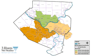
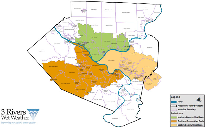
In January 2001, 3 Rivers Wet Weather invited the elected officials of the 83 ALCOSAN communities to participate in three geographically defined planning basins—the Eastern, Northern and Southern Basin Groups. All three basin groups, whose membership included at least two representatives (primarily elected officials) from each community and municipal authority in the basin, met regularly to learn about new regulations, share information and resources, and communicate with regulatory agencies through a unified voice.

The Basin Groups were created with the following goals:

  • Develop strategies for cost-effective basin-wide solutions to sewer system rehabilitation
  • Attract funding for multi-municipal projects
  • Communicate with fellow municipal officials and constituents
  • Help identify and overcome barriers to regional cooperation
  • Evaluate options for regionalizing the sewer system, build a consensus for the most optimal regionalization approach option and develop an implementation strategy

In early 2004, after nearly two years of working together with the regulatory agencies, the basin group communities signed municipal consent orders that require assessment, repair and long-term wet weather planning activities spanning through 2015.  Shortly after municipalities signed the order, 3RWW started meeting regularly with municipal engineers and managers in each of the three basins to begin regional compliance activities, such as manhole mapping and flow monitoring.

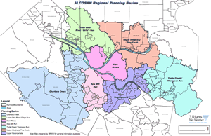
In 2008, ALCOSAN received a federal consent decree that requires the publicly owned treatment plant (POTW) to work with its service area communities in completing feasibility studies and long-term wet weather control planning. Through the basin group process, 3 Rivers Wet Weather created and facilitates a group of basin engineers in Feasibility Study Work Group meetings to examine alternatives for reducing, storing, conveying or treating wastewater flow in their municipal collection systems. Due to the complexity of the feasibility studies and long-term planning challenges, the Eastern, Northern and Southern Basin groups have been further defined by ALCOSAN into seven planning basins

3 Rivers is committed to supporting the communities throughout the ALCOSAN service area in the collaborative process required to develop a long-term viable wet weather plan. The basin groups have served not only as an effective vehicle for inter-municipal cooperation, but they also lay the foundation for consolidation of the sewer collection system, a critical key for a cost-effective, sustainable solution to the sewage overflow problem.

Download Basin Group Map

Click on a basin group below for a list of communities.

Eastern Basin Group Communities

  • Braddock 
  • Braddock Hills 
  • Chalfant 
  • Churchill 
  • City of Pittsburgh 
  • East McKeesport 
  • East Pittsburgh 
  • Edgewood 
  • Forest Hills 
  • Monroeville 
  • North Braddock 
  • North Huntingdon 
  • North Huntingdon Municipal Authority 
  • North Versailles 
  • North Versailles Municipal Authority 
  • Penn Hills 
  • Penn Township 
  • Plum 
  • Plum Municipal Authority 
  • Pitcairn 
  • Rankin 
  • Steel Valley COG 
  • Swissvale 
  • Trafford 
  • Turtle Creek 
  • Turtle Creek Watershed Association 
  • Turtle Creek COG 
  • Verona 
  • Wall Borough 
  • Wilkins Township 
  • Wilkinsburg 
  • Wilkinsburg-Penn Joint Water Authority 
  • Wilmerding 

Northern Basin Group Communities

  • Allegheny Valley COG 
  • Aspinwall Borough 
  • Avalon 
  • Bellevue 
  • Ben Avon 
  • Ben Avon Heights 
  • Blawnox Borough 
  • City of Pittsburgh 
  • Emsworth Borough 
  • Etna Borough 
  • Fox Chapel Borough 
  • Franklin Park 
  • Girty’s Run Joint Sewer Authority 
  • Indiana Township 
  • Kilbuck Township 
  • McCandless 
  • McCandless Township Sanitary Authority 
  • Millvale Borough 
  • Neville Township 
  • North Hills COG 
  • O’Hara Township 
  • Ohio Township 
  • Ohio Township Sanitary Authority 
  • Quaker Valley COG 
  • Reserve Township 
  • Ross Township 
  • Shaler Township 
  • Sharpsburg Borough 
  • West View Borough 
  • West View Water Authority

Southern Basin Group Communities

  • Baldwin 
  • Baldwin Township 
  • Bethel Park
  • Bethel Park Municipal Authority 
  • Brentwood 
  • Bridgeville 
  • Carnegie 
  • Castle Shannon 
  • Char-West COG 
  • Chartiers Flood Control Authority 
  • City of Pittsburgh 
  • Collier Township 
  • Collier Township Authority 
  • Crafton 
  • Dormont 
  • Green Tree 
  • Heidelberg 
  • Homestead 
  • Ingram 
  • Kennedy 
  • McDonald 
  • McDonald Sewage Authority 
  • McKees Rocks 
  • Mt. Lebanon 
  • Mt. Oliver 
  • Munhall 
  • North Fayette 
  • Oakdale 
  • Peters Township 
  • Pleasant Hills 
  • Robinson Township 
  • Robinson Township Municipal Authority (MATR) 
  • Rosslyn Farms 
  • Scott Conservancy 
  • Scott Township 
  • South Fayette Municipal Authority 
  • South Fayette 
  • South Hills Area COG 
  • Stowe Township 
  • Thornburg 
  • Twin Rivers COG 
  • Upper St. Clair 
  • West Homestead 
  • West Mifflin 
  • West Mifflin Sanitary Sewer Municipal Authority 
  • Whitaker Borough 


Download Planning Basin Map

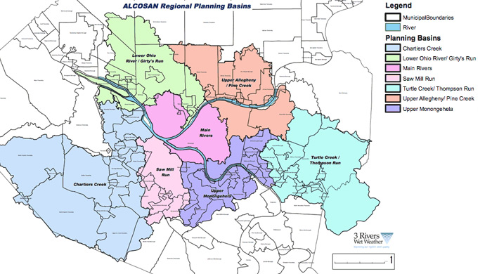
Click on a planning basin below for a list of communities.

Chartiers Creek

  • Municipality of Bethel Park
  • Bridgeville Borough
  • Carnegie Borough
  • City of Pittsburgh (PWSA)
  • Collier Township
  • Crafton Borough
  • Green Tree Borough
  • Heidelberg Borough
  • Ingram Borough
  • Kennedy Township
  • McDonald Borough
  • McKees Rocks Borough
  • Municipality of Mt. Lebanon
  • North Fayette Township
  • Oakdale Borough
  • Peters Township
  • Robinson Township
  • Rosslyn Farms Borough
  • Scott Township
  • South Fayette Township
  • Stowe Township
  • Thornburg Borough
  • Upper St. Clair Township

Lower Ohio River/Girty's Run

  • Avalon Borough
  • Bellevue Borough
  • Ben Avon Borough
  • Ben Avon Heights Borough
  • City of Pittsburgh (PWSA)
  • Emsworth Borough
  • Franklin Park Borough
  • Girty's Run Joint Sewer Authority
  • Kennedy Township
  • Kilbuck Township
  • McCandless Township Sanitary Authority
  • Millvale Borough
  • Neville Township
  • Ohio Township
  • Reserve Township
  • Ross Township
  • Shaler Township
  • Stowe Township
  • Town of McCandless
  • West View Borough

Main River Basin

  • City of Pittsburgh (PWSA)
  • Reserve Township
  • Ross Township

Saw Mill Run

  • Baldwin Township
  • Municipality of Bethel Park
  • Brentwood Borough
  • Castle Shannon Borough
  • City of Pittsburgh (PWSA)
  • Dormont Borough
  • Green Tree Borough
  • Municipality of Mt. Lebanon
  • Scott Township
  • Whitehall Borough

Turtle Creek / Thompson Run

  • Braddock Hills Borough
  • Chalfant Borough
  • Churchill Borough
  • East McKeesport Borough
  • East Pittsburgh Borough
  • Forest Hills Borough
  • Municipality of Monroeville
  • Municipality of Penn Hills
  • North Braddock Borough
  • North Huntingdon
  • North Versailles Township
  • Penn Township
  • Pitcairn Borough
  • Plum Borough
  • Trafford Borough
  • Turtle Creek Borough
  • Wall Borough
  • Western Westmoreland Municipal Authority
  • Wilkins Township
  • Wilkinsburg Borough
  • Wilmerding Borough 

Upper Allegheny / Pine Creek

  • Aspinwall Borough
  • Blawnox Borough
  • City of Pittsburgh (PWSA)
  • Etna Borough
  • Fox Chapel Borough
  • Indiana Township
  • McCandless Twp. Sanitary Authority
  • Municipality of Penn Hills
  • O'Hara Township
  • Ross Township
  • Shaler Township
  • Sharpsburg Borough
  • Town of McCandless
  • Verona Borough
  • Wilkinsburg Borough

Upper Monongahela

  • Baldwin Borough
  • Braddock Borough
  • Braddock Hills Borough
  • Brentwood Borough
  • City of Pittsburgh (PWSA)
  • Edgewood Borough
  • Homestead Borough
  • Mount Oliver Borough
  • Munhall Borough
  • Municipality of Penn Hills
  • North Braddock Borough
  • Pleasant Hills
  • Rankin Borough
  • Swissvale Borough
  • West Homestead Borough
  • West Mifflin Borough
  • Whitaker Borough
  • Whitehall Borough